
Canal and River Walk Inspiration
Cities around the world have transformed their economies by developing waterfronts that attract residents, tourists and investment.
Check out our Certificate of Incorporation here: Albany Waterway, Inc.

Introduction
The Albany Basin is labeled and clearly visible in the right center of this 1857 city map. Note the location of State Street and the 4000 foot pier that protected the harbor from the Hudson River. At the map's right edge is the entrance of the Erie Canal.
1857 Albany City Map

Cities don't stand still; everyday they are either expanding or decaying and the determination as to which of these directions a city is headed is decided by the actions of its people. During the last couple of decades we have all heard the success stories of many aging cities in the U.S. that have risen like the phoenix to become vibrant places to live, work and visit. The common threads of all these successes are leadership, boldness, commitment, and the willingness to overcome the relentless criticism from the ever present pessimists; thank god for all of those leaders who never listened to "it can't be done".
Our forefathers had the foresight and determination to dig, often by hand, over 500 miles of canals, with Albany as the gateway. Anything we do today is sure to pale in comparison to their original canal endeavor, and let us also not forget the economic value of their bold effort; the canal made New York the Empire State.
Today we have an opportunity to rekindle our heritage, to act boldly, to put life back into our capital city. Whether or not the Albany Canal and Broadway Boat Basin is the solution is yet to be determined, but it will take thinking and commitment of this magnitude to make Albany the great city it once was. We are blessed with the majestic Hudson River, our canal heritage and wonderful architecture. Many of the world's great cities have made much more with far less. Let us not squander our priceless resources.
Historical Context
Albany has a rich and long history. Henry Hudson sailed the Half Moon here nearly 400 years ago. In 1614, Hendrick Christiansen constructed the first European building in New York State on this city's riverbank. It was the Hudson River that spawned our capital city and gave it vigorous life. From the early days of Dutch yachts and English sloops to the mighty side-wheeled steamboats of a century ago, Albany had a bustling harbor right at the foot of State Street. The Albany Basin as it was known was bounded by Quay Street on the west side and an earthen-filled pier, that extended over 4000 feet in length, on the east. Thousands of vessels passed through the basin's portals during the city's golden age.
This painting depicts the city of Albany New York in 1868. The viewer is looking west over the Albany Basin. The front row of buildings are built on a pier which extended from one end of the basin to the other. The two domed buildings in the right background are City Hall and the Court of Appeals Building.
Albany in 1868

For most of Albany’s 400 year history there has been a harbor downtown.
The Old Erie Canal
The original Erie Canal began in Albany and extended 363 miles to Buffalo. Lock 1 was located at the north end of the Albany basin and marked the beginning of the lumber district. The actual canal mouth is marked by the site of the weighmaster's office. The function of this structure was to weigh barges and set fees for transit. Note that along the path of the canal are numerous slips that service the lumberyards. Between Montgomery Street and Centre Street, the block identified as Burt's Brewery is the present site of the Central Warehouse building.

Weighmaster’s Office, Albany, NY, circa 1855.

The detail from the 1857 map, depicts the entrance of the Erie Canal.

Lock 1 of the Erie Canal, Albany, NY, circa 1855.
The Albany Riverfront

This painting of the Albany riverfront in 1852 depicts Steamboat Square at the south end of the Albany Basin.

This article appeared in the Albany Times Union June 7, 1996. It was the first time the public was made aware of the canal idea.
Albany was always the busiest hub of passenger and freight activity on the Upper Hudson River. In the early 1800's, with new territories opening up to the west, many thousands of travelers passed through the portals of this great capital city. Passengers bound for points west could depart directly from Steamboat Square via several railway lines or Erie Canal packet boats. Albany was corning of age and its steamboat landing showed all the trappings of an up-to-date, active urban space. Among the warehouses that crowded the Square were numerous hotels and the city's finest restaurants.

The present day Albany riverfront evolved from a busy commercial port to an inaccessible, massive and impenetrable bulkhead.
Albany, the largest city on the upper Hudson River and the capital of New York State no longer welcomes mariners.
The Idea

Albany area of detail

Broadway near the corner of State Street
For the last 30 years, numerous studies have been made for reconnecting Albany to the Hudson River. In April of 1969 Candeub, Fleissing and Associates developed a plan for Mayor Erastus Corning which basically called for the relocation of a major portion of the downtown area to the what is now the Corning Preserve. Their idea would have been achieved by spanning Interstate 787 with a 750 foot wide bridge complete with infrastructure. This was an idealized design and did not reflect realistic urban growth. Since then there have been many plans with greater and lesser merits. Some called for the elevation, sinking and even removal of the major obstacle that prevents the city from reaching the water, the interstate highway.
The canal suggestion is based on two fundamental facts; the center of downtown Albany is not moving and neither is the highway. The proposition is quite simple, bring the river under the interstate and directly into town.
If you can’t bring the city to the river bring the river to the city.

This sketch gives a sense of the impact of a waterway in downtown Albany.
Broadway Boat Basin
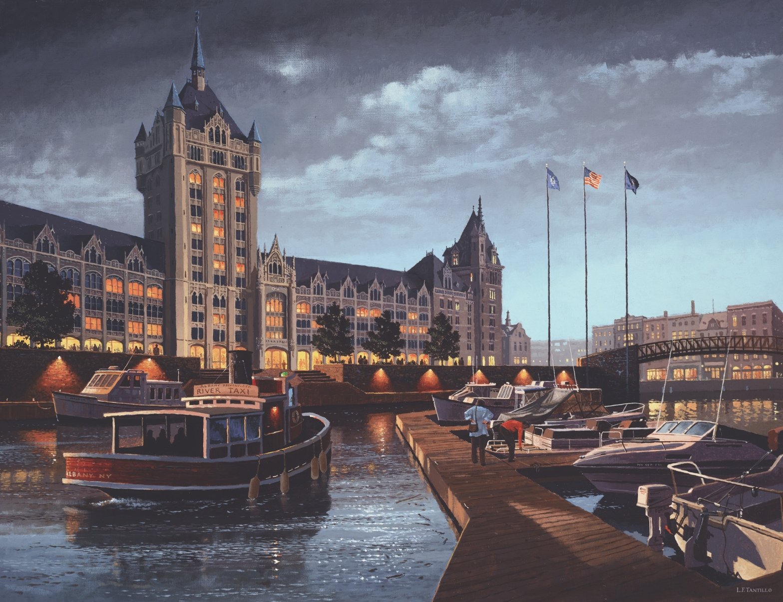
The Delaware and Hudson Building was intended to block the view of the Hudson River from State Street and downtown Albany. The architect for this beautiful building was the great Marcus T. Reynolds, who tried initially in 1910 to persuade city officials not to place a building at the foot of the hill. His original plan, for a public square and yacht club, was rejected and in the end Reynolds designed one of upstate New York's most majestic structures.
Since the completion of the D&H Building in 1918, Albany and the Hudson have undergone many changes. The horse and buggy gave way to the automobile and industrial pollutants, that once contaminated the river, are diminishing. We have once again begun to appreciate our natural resources. Commercial usage of the river declined throughout the 20th century, but, with more leisure time and disposable income, recreational boating has grown at an almost geometrical rate. In 1995, it was estimated that 150,000 pleasure craft passed through the Erie Canal.
One of the most spectacular changes that could come from the construction of a downtown canal would be the Broadway Boat Basin in front to the D&H Building. This glorious gothic structure could become an incredible backdrop reminiscent of the Houses of Parliament in London or Saint Mark's in Venice.

The Albany Canal would dramatically change the city. Note that the image depicts the marina in front of the D&H Building, in the evening. Waterways of this type have provided many other US cities with a life after 5 PM.

The original concept plan from 30 years ago!
Overall Site Plan
One of the decisions we made in preparing this canal plan was to produce a scheme that pulled out all the stops. What would the ultimate design idea become if cost and physical design problems could all be solved? Alternative ideas were explored and are included, but the primary focus was set on a bold plan for Broadway.


We already have the most important element in this grand scheme; a river that connects us with the rest of the world.

One of the greatest assets of this city is its 19th century street facades. This row, along Broadway, is in good condition despite the fact that the ground floor struggles for tenants.
We already have the most important element in this grand scheme; a river that connects us with the rest of the world.
One of the greatest assets of this city is its 19th century street facades. This row, along Broadway, is in good condition despite the fact that the ground floor struggles for tenants.
The presence of a waterway on the doorstep of the buildings could create a boom to business in the entire downtown area. This profound and unique change cannot be matched in any local suburban shopping center.
The Archeology

The center of the early Dutch village of Beverwyck was near the intersection of present day Broadway and State Street. Some of the secrets of our most important historical era lie under the ground at this site.
Over the last three centuries the land al the intersection of State Street and Broadway has been built on many times. In the l700's two of the city's most significant buildings, City Hall and the First Dutch Church. were located there.
Shortly after the Dutch arrived in 1609 development in the Albany area began. The trading house at Fort Nassau (near present day Port of Albany) was built in 1614. The community was established in a more permanent way in 1624 with the construction of Fort Orange. By the early 1640's the population had outgrown the walls of the little wooden fort and the village of Beverwyck sprung up. It was centered at the site of the present day intersection of Broadway and State Street. Although this part of the city was built on many times over the centuries it holds many secrets about our earliest history. If the canal and boat basin project were to proceed at this location, it could provide archeologists with an unprecedented opportunity to study the largest and most important historical site in upstate New York. Part of the organization and planning of this project should take into account the time and capital required to extract the maximum amount of information from this land.

Detail from the painting, Return of the Experiment by L.F. Tantillo
Never would there be an opportunity for archeologists to study so much of Albany’s past as the same time.
Concerns
This conceptual design project did not include an in-depth feasibility study. We looked into site mechanics and underground utilities only in the most general way to determine if the canal excavation and construction were possible. We believe hat there seems to be no obvious major obstacle that would inhibit the work. Only a full scale study of the site by a team of experts can ascertain the actual feasibility of this proposal.
The two major areas of concern appear to be a major water main and the railroad tracks to the Port of Albany. The 48" cooling water supply pipe to the Empire State Plaza cuts directly across Broadway just south of the D&H Building. Because the water is forced through the pipe under pressure it may be possible to reconfigure or relocate the line. The railroad tracks are problematic only at the north end of the canal system. Construction of a swing or lift bridge would be required to accommodate boat traffic at that location.
The water level and potential flooding of the canal were also examined. Flooding would have to be controlled at the entrances to the system with mechanical gates that could close as conditions demanded. The subject of locks to elevate boats within the system was discussed at length. Two very different opinions have emerged. On one side, a locked system provides more controls and minimizes the effect of a height differential between the street and the water. A system without locks allows for easy boat traffic into and out of the system without lining up and waiting your tum to enter. The water level in some places would be 15 to 20 feet below the street, at low tide. This is actually an advantage when pedestrian and vehicular traffic over the canal are considered.

Diagrammic cross section of Broadway at 48” cooling water supply line.
Options


Conclusions
After reviewing this report it should be quite clear that the capital of the Empire State has great potential for regaining its rightful place as one of America's most beautiful cities. We believe that in order to accomplish this it is necessary to look back at our illustrious past and examine how some of those wonderful elements can be integrated into a bright future.
The overall canal design (a system that begins at the south end of Broadway and extends through the city to the area near Central Warehouse) would take tremendous commitment and financial resources. The rewards for such an effort, however, are potentially enormous. Thousands of jobs, new business opportunities, increased tourism, and a monumental increase in land values and revenues are only some of the benefits.
The system need not be constructed all at once. As demonstrated in the various options presented, portions of the system can be built as part of a the phased larger project. These individual projects can function as complete entities and also serve as a test for the viability of an expanded waterway.
We believe that at the very least, the city of Albany needs a substantial public marina and that such a facility must exist downtown, on the inside cf the current interstate highway right-of-way. The time for action is here. The Hudson is cleaner than it has been in the last 30 years, the boating industry is expanding at an almost geometrical rate and Americans are still attracted to waterfront cities.